5 June 2013

Back to Argentina

Leaving Bolivia we had a freezing cold but relatively swift crossing back into Argentina heading torwards Buenos Aires. We had a stop in Salta and Rio Horno before heading to a working cattle ranch for a few days. We all thought the ranch was going to be a lot of “yee ha” and we would learn to lasso cows and feed the animals. It wasn't that at all but it was a nice place to chill for a couple of days. I went on a horse ride with Jane and it was by far the best of the trip so far. The ranch is 70km from the main road so we couldn't see any signs of life as we pushed our way through very thorny bushes. Our legs were thankfully protected by some sort of cow skin cover over them. It was great fun and we even got to gallop. The photo is of us in a wooded area where there were cattle gathered around a watering hole. They were huge!! Next on our route was our last camp in a town called Rosario which is apparently famous for being the birth place of Che Guevara.

We arrived in Buenos Aires in time for a bit of a party. Kirsten had made a slide show and then we headed out for a nice group meal, a few drinks and I even managed to fit a helping of brownie and ice cream in at half midnight! The following morning everyone went their separate ways, with some not willing to let the holiday end by going to Uruguay for 10 days as an extra trip add on. It was sad seeing everyone go and I really hope some paths with cross again in the future. As for me, I moved into a hostel for 3 nights. It's been great to chill out and not have to get up whilst it's still dark. I've also explored the city to the max now, going places I didn't go first time around, visiting the zoo, botanical gardens and congress square. Time to go home tomorrow and back to work but it really has been a fantastic 6 and a bit months. It's hard to pick a favourite country or experience so I've compiled a photo of the “top 10” below. Ciao for now.

Iguassu Falls, Argentina and Brazil

The 'W' trek, Chile

Los Glaciares National Park, Argentina

Scuba diving, Cartagena, Colombia

Galapogos Islands, Ecuador

Climbing Mount Villarica, Chile

Cycling down 'Death Road', Bolivia

Angel Falls, Venezuela

Machu Picchu, Peru

Canyoning, Venezuela

27 May 2013

Tupiza, Bolivia

Some days just don't go to plan and the drive Uyuni to Tupiza was one of them. The roads in Bolivia have been lovely smooth tar but our luck had run out and the road we had to use was 200km of corrugated dirt road. The scenery was amazing though, with mountains of all colours, flat scrub land, dried rivers it was one of the most scenic days of the whole trip. Sadly the day was slow and just as we were on our final leg we were faced with a bus with a flat tyre. We aren't entirely sure why it took them 1.5 hours to change a tyre but they did a lot faffing first meaning that we rolled into the completely un-signposted Tupiza at about 9pm.

I was a bit worried that I wasn't going to be able to organise a tour of the area which is Butch Cassidy and the Sundance Kid territory (they committed suicide in the nearby town of San Vincent after being on the run). Myself, Jeanne, Lisa and Francois went on a lovely 4 hour walk to see some cool rocks and canyons. A stretch of the legs is definitely what we need as we have a 12 hour plus journey back into Argentina ahead. Bolivia has been a great country to visit. The highlights though have definitely been the amazing scenery and a huge number of dogs in clothes!!

Uyuni, Bolivia

We had quite a short and scenic drive from Potosi to Uyuni arriving in time for an afternoon of relaxation before a full day touring the salt flats the following day. Another must do of Bolivia, I was looking forward to getting out for the day but I couldn't help but think all we were going to see was a lot of white salt!

We left Uyuni in a convoy of 4 land cruisers and our first stop was a visit to a train graveyard. It was pretty cool to climb all over the rusted engines and you could of spent ages taking photos but sadly it was just a brief stop. Next we visited and area where the salt is locally processed by drying and crushing before being bagged for selling within Bolivia. The Uyuni salt flats are the biggest in the world and are larger than Lake Titicaca. The flats were once saline lakes, 90m deep in places. 12,000 years ago a volcano erupted and lava poured into the lakes and evaporated the water leaving behind salt deposits up to 27m thick in places. Our first stop was to an area on the edge of the flats where they are digging up the salt and putting it in 1000kg piles ready for collection. The salt was only thin in this area and there was a lot of water around, making for very pretty photos!

To get a sense of the size of the flats we drove for an hour of so to an island where huge cactus' are growing. After lunch on the way back to Uyuni we stopped so that some silly photos could be taken. A camera is able to focus on objects in the foreground and background as landscape is so white, what is close and far away can't be registered. This means that you can have a perfectly in focus shot of someone sitting in someone elses hands or emerging from a wine glass. Watching people trying to take these photos was funnier than actually being in the photo yourself! We finished the day by watching the sun set and the moon emerge which gave us another photo opportunity to try and hold the moon. I tried to be more original and went in for kicking the moon. Overall is was a much better day than I expected but ultimately what we saw was just a lot of salt!!

24 May 2013

Potosi, Bolivia

Potosi is a little town which in its silver mining heyday from the 1500's used to be the size of London. The town is overlooked by a big orange coloured mountain which was once full of silver. The Spanish funded the mining and sent the silver back to Spain in huge galleons. 8 million people died in 300 years from mining the mountain and it was said that enough silver was mined to build a bridge to Spain. Some of the group went on a tour around the mines as its still mined today on a what you find is what you keep, so some people are mining for silver and others what ever they can find. I didn't join them as it would have been a little to claustrophic for me as they are still mining they same way as they did 500 years ago. Most came back having enjoyed the experience especially being able to buy dyanamite in the miner's market!

Potosi is also home to the National Mint which is now a museum. It was interesting to see inside in the building as also see how the minting of coins changed from 1773 to 1951 when the mint was in use, moving from mule driven power to steam and then electric power. My only fun fact that I remember is that now Bolivia has its coins made in Chile and its notes made in France.

It was also Kirsten's birthday so we felt it was fit to celebrate with a day of eating food. Yum!

21 May 2013

La Paz, Bolivia

Getting into Bolivia was an absolute doddle. No queues, no computers, just stampy stamp and we were away and into the tiny town of Copacabana for a couple of nights. Copacabana is on the edge of Lake Titicaca and off shore is the Island of the Sun, thought to be the location of the creation of the Incan empire. Some of the group went off to explore but most of the group stayed on dry land choosing to chill in the outdoor cafes, mooch the shops, recouperate or be ill in bed (maybe not a choice). After all the excitement of the last week it was nice not to have a lot to do and be able to charge the batteries.

We left Copacabana and headed to La Paz on the more exciting route which involved a short but choppy boat trip across a narrow section of Lake Titicaca. It was a bit nerve racking watching Ithaca heading onto the barge but it turned out to be a lot simpler than in Porto Velho. We turned up a very rainy La Paz at lunch time to be faced with road blocks and protests so we had to ditch the truck at the side of the main road after we couldn't get any parking. We headed to the hotel in taxis and Kirsten and Rogan would return later to find somewhere to park.

La Paz is the unofficial capital of Bolivia with Sucre being the official capital. La Paz was originally created as part of a trading route linking the south of Bolivia with Cusco, Peru. The city is expanding up the side of a valley with an altitude range of over 1000m leading to temperatures ranging 8 degrees from the top to bottom of the valley. The city doesn't have a nice main square and no visible main restaurant or shopping streets and is generally not very user friendly, so some of us took a morning city tour to see if there was anything more to the city. Our first stop was the Valley of the Moon. This is an area of eroded rocks into a moon- like landscape. It's a bit random but it was a nice stop. We also visited a city view point, a couple of museums, a very pretty street (the only one in the city I think) and also the witch's market where they were selling all sorts of natural potions and also dried baby llamas. It's thought that when you build a new house, if you bury a llama with the foundations you will have good luck!

About half the group signed up to go cycling down “Death Road” on the second day. This experience has been a must do since signing up for the trip and despite mum's concerns I did it anyway. The road has got a reputation from tv programs like 'Top Gear' and that truckers one for being “The world's most dangerous road” so for me I was curious to see what the road was actually like. We were picked up by our guide Marcus an Australian and kitted out with all the necessary gear to see us on our way which included a helmet, gloves, heavy trousers and jacket, a hi vis vest, and a downhill bike, built with full suspension and weight to go over anything in our way. Our journey would start at 4700m with snow on the ground around us and we would make our way to 1200m passing through 5 climate zones. The first 20km or so was on tarmac so riding was smooth and we picked up some serious speed sadly the weather wasn't playing nice and we had sleet bombarding our faces. We then had 8km uphill which we all jumped into the bus for before heading down the unpaved road. The unpaved section is “Death Road” and we headed down hill on a variety of slopes and road widths. At the narrowest, the road was 3m wide and had a 450m drop off the side. The bikes were very stable even when going over big rubble but it was quite scary to think that no one else is in control but you and it was easy to see how you could go straight over the edge. Rules say that if you are going downhill you need to cycle on the left side, nearest the cliff and I think at some times we were actually thankfull that the mist was covering the drop!

The road now is mainly used for bike tours and also essential vehicles to the small villages you pass. “Death Road” gets its name from its history of having so many fatalities from buses going over the edge. This was before the new road was built in 2008 so now the old road has been left for the cyclists. It was an amazing day, not just the thrill of cycling down the road but also being able to see the scenery change and the weather. The actual cycling wasn't scary but coming back up the road in the bus with a sound system, strobe lighting and when it's dark, and raining was!

We left La Paz whilst it was still dark to try and avoid road blocks. We encountered a 6 hour wait later along the way in a small town where taxi drivers had blocked the road, something about wanting pensions. The delay forced us to have a very cold bush camp and we arrived in Potosi a day late. All is ok itinerary- wise as we can make up time through a longer drive day later on so we still have the same amount of time to explore Bolivia

15 May 2013

Puno, Peru

This morning we arrived at Puno on the shores of Lake Titicaca. The lake at 190km long and at an altitude of 3830m is the highest navigable lake in the world and is home to 2000 Uros people who live on the floating islands. The Uros were forced to live an island lifestyle after being forced to the lake by the Colla and Incas.

Took a boat trip to take a look at the islands. The totura reed grows in the lake but only in depths of 3m or less. The reeds are collected and we were able to be shown how they make an island from the reeds when we stepped ashore an island shared by 6 families. The islands can last for up to 70 years after they are initially built providing that a top layer of reeds is added regularly as the bottom layer rots away. It made a bit of an odd surface to walk on but the families manage fine making canoes and theie homes out of the reeds. They shoot the lake birds and catch fish. If they want anything else they barter in Puno for it. Tourism has helped the Uros people carry on living like this as they make handicrafts which we didn't have a problem buying. The islands didn't feel touristy though as it's carefully controlled and each island gets its fair share of boats so trade is spread. There are 40 islands which live solely off what they can make and catch as they live further inland and don't receive any tourists. It was a fantastic morning out and I'm looking forward to seeing the other side of the lake when we head to Copacabana in Bolivia tomorrow.

14 May 2013

Cusco, Peru

Cusco is a lovely town in itself and there is plenty to keep you busy. Some have gone off trekking for a couple of days in the Lares Valley and others, me included have spent the time mooching around the shops, buying so much stuff that you don't have room for and eating lots!

Cusco

The Sacred Valley is a must do from Cusco so we spent a day packed on a mass tourist bus trip to see what it was all about. Our first stop, after the compulsory toilet and souvenir stop was to the ruins of Pisac. Pisac was built in the 14th Century as a means of growing food and storing it for the nearby villages. There are amazing examples of Inca terraces at the site, with each terrace being 7m higher that the last. The Incas were clever and through this terracing system creating irrigation with the water coming from the glaciers feeding the upper terraces first, they manged to create micro climates enabling 1500 species of corn and 3000 species of potato to be grown! Although a ruined site, there is a walking track which goes to Cusco so the locals are still using this area today to go along with daily chores.

Pisac

We visited the Ollantaytambo ruins after lunch which was the Temple of the Sun. The huge pyamidal ruin is unfinished as the Spanish invaded and interrupted the Incas' building. What was already there was started in the 1570's and took 8 years to build. It was massive!! Our guide explained about the 2 different types of building that we could see. Simple is where the stones are roughly cut and then fixed with mortar which is what a lot of the lower levels of the complex were. The upper levels were more complexly built as the stones were cut so that they fit together perfectly without any mortar. The Incas were also clever enough to earthquake proof the temple by cutting the blocks to a slight slope, and using large blocks of stone at the top of the temple separated with some smaller cut rocks to absorb shock. The temple itself was impressive but its location situated at the junction of the Lares, Sacred and Machu Picchu valleys was spectacular.

Ollantaytambo

On the way home we stopped briefly at a centre in which some of the Quecha speaking locals still living a traditional life showed us how they use create the wool used in their weaving and how they dye using national products. We also took a brief look at the Chincheros ruins which have had a colonial town plonked on top of them when the Spanish arrived. It was a great day and so far we haven't been too ruin-ed out!

Chincheros

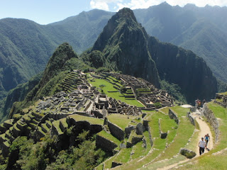
The reason for visiting Cusco is to go to visit “The lost city of the Incas”, Machu Picchu. It is known as the lost city because the Incas abandoned it when the Spanish arrived in Peru in the hope of them not finding it. They didn't and it remained jungle covered until 1911 when an American found it after a local tip off. It was a hell of a journey to get there and back which meant getting the train (complete with sunroofs to see the top of the mountains) and then staying overnight in a town called Aquas Callientes. The next morning we awoke at 4.30am to then get one of the first buses up to Machu Picchu to try and avoid some of the crowds. Usually you would head straight to the “Sun gate” to see sunrise but as it was a cloudy morning we let the other tour groups go there and went to take photos of the city from a terrace. It was amazing to be able to take photos with no people in them!! We had a 2 hour tour covering some of the main things to see.

Temple of the Sun, one of the 4 temples in the city which would have once been covered in gold and the only temple which still has its gold rock brackets in place.

We also saw houses, a factory, the watchman's house and the temple of the Condor. The temple would have been used for sacrifice of young girls only as offerings to the gods. Sacrifice was popular on 21st June which is the winter solstice, when the sun was furthest from the city so the sacrifice was made as an offering for the suns return.

Some of us also took the opportunity to climb Wayna Picchu the cities Northerly sacred mountain. It was pretty steep but the top provided an amazing view of the city and allowed you to see just how remote it was.

It was great seeing Machu Picchu and worth the journey (on the train) as it was a nice suprise that it was half as crowded as I thought it would be.

Sadly I spent the last day in Cusco with a stomach bug which has wasn't the most pleasant but at least it stopped me shopping, gave me a duvet day and I seem much better now!